Friday, October 1, 2010

Sloan Peak - 8/14/10

Sloan Peak Corkscrew Route

We met at Mark’s house in Vancouver at 5 a.m. and loaded up the car in the dark before beginning the long drive to Darrington, Wash. Introductions took place in a dark driveway followed by a dark car ride. It was strange meeting people in person for the first time and not actually seeing them for a couple hours. The only members of this team I knew before this trip were Chris and Kevin, whom I’d met briefly on the summit of Unicorn Peak a few weeks ago.

Fortunately traffic was light and we had no problem getting to the trailhead on time. We stopped at a local grocery store to pick up lunches. I ended up with a Lunchables box, which came as a complete meal with cheese and crackers and a juice box, along with Skittles for dessert!

The hike in was fairly uneventful. The approach trail is unmaintained and has a reputation for route finding challenges, brush, gnarly river crossings, and mosquitoes. There were some sketchy log crossings and the trail was quite overgrown in some areas, but none of these issues caused us significant problems. I managed to keep my feet dry for the entire approach.
Others were not so concerned about staying dry

We had some difficulty locating a decent camp spot large enough for our group of seven. I set up my bivy bag in a cleared area next to a fire ring, but the rest of the group setup their tents in the open meadow below.
The only flat spot large enough for our group

After the Lunchables meal I had for lunch I continued with the kid’s food theme and had macaroni and cheese for dinner. Unfortunately I forgot to add the tuna I’d brought until after I’d eaten the mac n’ cheese and ended up having to eat an entire package of tuna plain, which I’m not especially fond of.
Slabs approaching the glacier

The next day began with a scramble up some steep rock slabs to gain the North Moraine of the Sloan Glacier.

Crossing the glacier

Ordinarily the glacier would be very broken up this time of year, but due to the late spring snows we had this year, the crevasses remained mostly covered.
Corkscrewing climber's trail
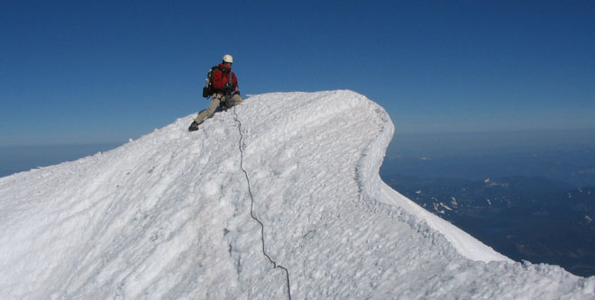
After crossing the glacier the climb continues on a climber’s trail with some fun scrambling that corkscrews around the mountain (hence the name of the route), eventually leading to the summit.
View from the top

On our way back to camp the glacier crossing was painfully slow. Although it wasn’t particularly steep or crevassed there were a few members of our group who weren’t especially comfortable with the soft snow that balled up under our crampons, making for slippery footing. After making it across the glacier I used a standing glissade to descend snow fields back to camp, which made for a quick descent.

We packed up camp and hiked out the way we came. We had planned to possibly stay an extra night depending on how long the climb took. It was nice to get home early and have an extra day left on the weekend.

The dining options in Darrington are fairly limited. We opted for a bar donning a sign that read, “Biker and Family Friendly.” I figured with that type of endorsement we couldn’t go wrong. The service was good and the food was actually pretty satisfying. They had some monster hamburgers which are perfect post-climb fare.

This was an exploratory trip for our leader Kevin, meaning he’d never climbed this route before. It was obvious he’d done quite a bit of research on the route before leaving town. Thanks to his preparedness the trip went very smoothly and everyone had a great time.

Thursday, July 22, 2010

Sahale Arm - 7/17/10

As I left the house at 2:30 a.m. Friday I felt mostly rested, but my body did not appreciate being roused at such an unusual hour. After collecting Hye and Shayna, we arrived at the Marblemount Ranger station in a respectable 5 hours from Northwest Portland. We hung out on the lawn for a bit while waiting for the rest of our crew to arrive, and once assembled, caravanned to the Cascade Pass trail head.

From here we began the march up to Cascade Pass. The weather was perfect: cool enough for hiking but with clear skies for unobstructed views. After resting on the patio at Cascade Pass we headed up the Sahale Arm proper. The higher we got on the Sahale Arm, the better the views. As we hiked I recalled the sign I saw posted as we rolled into the town of Marblemount welcoming us to "The American Alps". I’ve never been to Switzerland, but this area is very close to what I’ve imagined.
The hills are alive...

This climb could easily be done in and out in a long day from the trail head, but our trip was designed to flow at a more leisurely pace. Our plan was to camp at the base of the Sahale Glacier and summit the next day, then spend another night at camp before hiking out Sunday.

First break out of camp on Saturday

In addition to the views, one of the main advantages of camping at Sahale camp is that the summit is only 1,000’ away. Our group set off ~8 a.m. Saturday for the leisurely jaunt to the summit block. As we first headed out I was hopeful that we were getting an early enough start that we would have the mountain to ourselves that day. Unfortunately, being a group of 10 meant that there was a fair amount of standing around while our leader, Jeff, setup a fixed line and we each headed up to the summit one after the other. This additional time allowed for several other groups to catch up with us. By the time we were all on top, several other climbing parties were beginning their assault on the summit block from both the Quien Sabe and Sahale Glacier sides of the mountain. After a few quick photos, we made an orderly rappel descent to make room for the other groups.

Hanging out on top

The rest of the afternoon was spent hanging out in camp taking naps, snacking, and even a bit of Hacky Sack. There were a couple of goats that hung around camp for most of the weekend, which also kept us entertained. The wind kicked up quite a bit Saturday evening, which meant interrupted sleep for many of us.

Home sweet home

The Loo With a View

Photo taken while using the Loo With a View. Intimidated the poop out of me...literally.

After the hike out on Sunday everyone seemed tired, hungry, and ready for a nap, so we stopped at the Skagit River Brewery in Mount Vernon to refuel before continuing the long drive home. I had a good time getting to know my team members on this trip since I didn’t know most of them beforehand. Thanks to Jeff for putting together a great trip!

I’ll be headed back to this area for a climb of Sloan Peak next month, so stay tuned for another trip report.

Tuesday, July 13, 2010

Unicorn Peak - 6/25/10

Our objective

Our objective this weekend was Unicorn Peak in the Tatoosh Range just south of Mount Rainier. Unicorn Peak is a very nice climb with a short approach and enough technical challenges to make it interesting but not intimidating for less experienced climbers.

We had reservations for a beautiful campsite at Cougar Rock Campground in Mount Rainier National Park. It was so pleasant that I decided to sleep outside Friday night even though I’d brought a tent.
Ready to go

On Saturday morning, the short hike in was all on snow. We were thankful for the wands and footprints of an unseen group ahead of us. We ate lunch at Snow Lake before donning crampons and heading up the couloir that leads from the lake to the upper flanks of Unicorn. It had been a while since most of our group had done anything with ice axes, so I gave a brief review on ice-axe use and self arrest, but we skipped practice due to the soft wet snow in the basin.

We caught up to a group of Mazamas at the base of the summit block and waited a bit for them to get their group on top. The weather was warm and sunny with little wind, so it was not a bad day to sit around.

Once the route was freed up I set up a fixed line and we all scrambled to the top without much difficulty. The view from the summit was one of the best I’ve ever had on a mountain. The sky was very clear and we could see at least 4 volcanoes clearly in the distance. Almost all of the area we overlooked was park or wilderness, so there were no distracting clear cuts and few signs of human activity.
On top, Rainier in the background

After soaking in the 360° panoramic vista and snapping some photos, it was time to descend. I lowered Sean, Lindsey and Liz since none of them felt comfortable rappelling. I used a 96’ rope for this trip to save some weight. When it was time for me to descend the rappel was ~52’, which made for a fun finish on the doubled rap line which ended a few feet above the ground.

We easily descended in the soft snow until we got to a moat at the top of a snowfield not far from the summit. The Mazamas group had set up a rope here and members were rappelling one at a time down into and climbing back out of the moat. This took a while, but we decided to throw a rope over as well since there was a nice sling setup. Sean, Lindsey descended using prusiks, while Liz opted to rappel. I followed without a rope and was able to hop over a narrower section of the moat without any trouble.
Liz modeling the classic trash bag glissade pants

At the bottom of this snowfield Liz and Lindsey started glissading almost all the way back to Snow Lake!

The easy way down

We anxiously gobbled up the burritos that Liz prepared for us for dinner Saturday night and relaxed around camp before heading home Sunday morning. Overall this was a very pleasant trip with perfect weather and a great group of friends to enjoy it with.
Let the burrito digestion commence

Awesome weekend!

Monday, April 26, 2010

Timing is Everything - 4/25/10

I’ve been assisting with a Mazamas BCEP (Basic Climbing Education Program) class this year, which has been a good opportunity for me to refresh my skills and learn new teaching methods. On Saturday we had our snow skills field session near Timberline Lodge on Mount Hood. This was the final weekend of the class and it had been a couple of weeks since I’d worked with the students. This weekend I could really tell that they were starting to get comfortable with the gear and techniques they’ve been learning. They’re actually starting to look like climbers!

After the field work we headed to the Mazama Lodge for dinner and to rest up before Sunday’s activities. I’d never been inside the lodge before - it’s a very nice facility and the food we had for dinner was excellent!
Mazama Lodge

For Sunday the students were planning a hike to Illumination Saddle high on the southern flank of Mount Hood. Myself and two of the other assistants had planned a summit climb.
The weather was looking somewhat questionable for a summit bid; it had been fairly windy on Saturday, but not too cold. The forecast was for clearing overnight before becoming warm and sunny Sunday afternoon. It appeared we would have a good window early Sunday.

After some debate about what time we should leave, we decided on midnight. We wanted to be up and down before the forecasted sun and warm temperatures turned the snow to slush and started a barrage of falling ice high on the mountain. We also wanted to avoid the crowds that can typically be found on spring weekends.
This is the earliest start I’d ever had on Hood. I had never climbed with Don and Dan before, so I wasn’t sure how fast we would be. There was almost a full moon, so we didn’t need to worry about light too much and the idea of watching the sunrise from the highest point in Oregon sounded great.

After dinner at the lodge we crashed for a few hours in one of the basement rooms in the lodge.

Mazama Lodge Basement

By 12:30 a.m. we were one of the first teams headed up the mountain. The higher we got, the windier it got. After about a half hour of marching we stopped for a break at Silcox hut (~7000’). There were still a lot of clouds up high, but we were hopeful the forecasted clearing would come to fruition. We continued on to the top of Palmer (~8500'), where we were met with fierce winds and no opportunities for shelter. It was quite cold and we all added a few more layers. Dan decided the cold wind was a bit too much and decided to head back down. The clothing he had wasn’t as warm as what Don and I had brought, and his teeth were starting to chatter, so this was a wise decision.

Anxious to get moving again so we could warm up, Don and I continued up the mountain. The wind was continuous out of the West until we reached the elevation of Illumination Rock (~9600’). Here we found a brief but welcome respite for maybe 500’ of climbing. Soon the winds returned, but this time out of the East, carrying small ice pellets that sand blasted our faces.

I looked at my watch as we approached Crater Rock. It was 10 to 4:00 and the clouds were still obscuring the upper part of mountain and blocking the moonlight. By now we had passed every other team on the mountain. I suggested to Don that we needed to kill some time until it cleared or the sun came up, but it was too cold to stop moving and the only shelter from the breeze was now several hundred feet below us.

With very low visibility and driving snow we began to make our way around Crater Rock, hoping to find some shelter in the vicinity of the Hogsback. This is normally a trivial part of the climb as far as route finding goes, but in the dark with clouds and driving snow we couldn’t make out the usual landmarks, we had only the contours of the terrain to guide us. Being the first party up there also meant we had no footprints to follow. I was concerned about inadvertently wandering onto the upper part of the White River Glacier where I knew there were steep slopes and crevasses, so we ended up high on Crater Rock before beginning to traverse around the East side. Here we encountered steeper slopes than either of us remembered on this route and there was a layer of loose unconsolidated snow on top, which made for slippery footing. It was decision time. We had not adopted crampons yet because they were not necessary and the thought of stopping to put them on in the wind to traverse this slope was not appealing. Especially in light of the fact that if we did continue to press on we would probably end up waiting at the Hogsback for the clouds to clear. At this point we were highly skeptical that there would ever actually be any clearing and were not anxious to wait around in the cold and wind to find out.

In our quest to beat the cold we’d kept moving without many breaks and Don had been fighting freezing water bottles for a while. He was beginning to experience some leg cramps, likely as a result of mild dehydration. The combination of these factors led us to decide that it was time to head down. The wind continued to punish us as we descended. Once we got below the top of Palmer we started to catch glimpses of the upper part of the mountain.

View of the Top After Heading Down

By the time we reached the top of the Magic Mile chairlift the winds were starting to subside. Don continued to fend off the leg cramps as we descended, which reaffirmed that our decision to head down was a good one.
Sunrise

By the time we reached the lodge we could see the top of the mountain with climbers on the Hogsback. I’m sure many of them summited. If the forecasted warm weather and clear skies had come to pass their late start would have meant descending in loose, wet snow and potential ice fall. It turned out that on this day those who slept in a few extra hours may have ended up with an advantage.


I’m a bit disappointed at not summiting, but have no regrets. I learned some lessons about weather and timing. It was a good opportunity to test my gear and fitness, which all passed muster this time around. I enjoyed climbing with Don and Dan and look forward to doing so again in the future. Overall it was a good day in the mountains!